Projects & Research

Patterns and Pathways of Planetary Urbanization

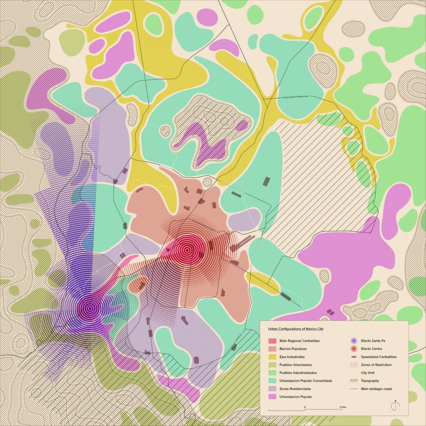
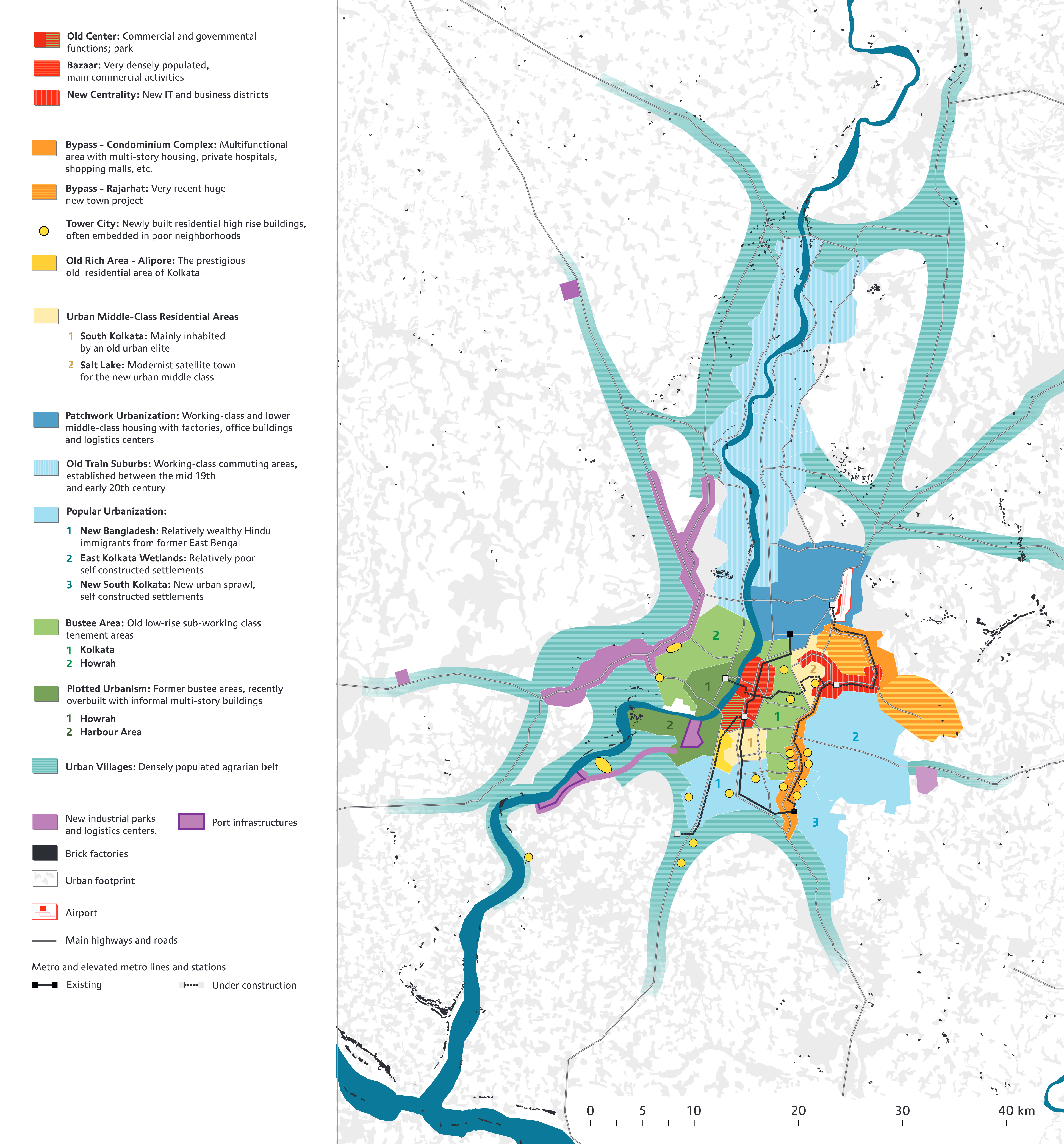
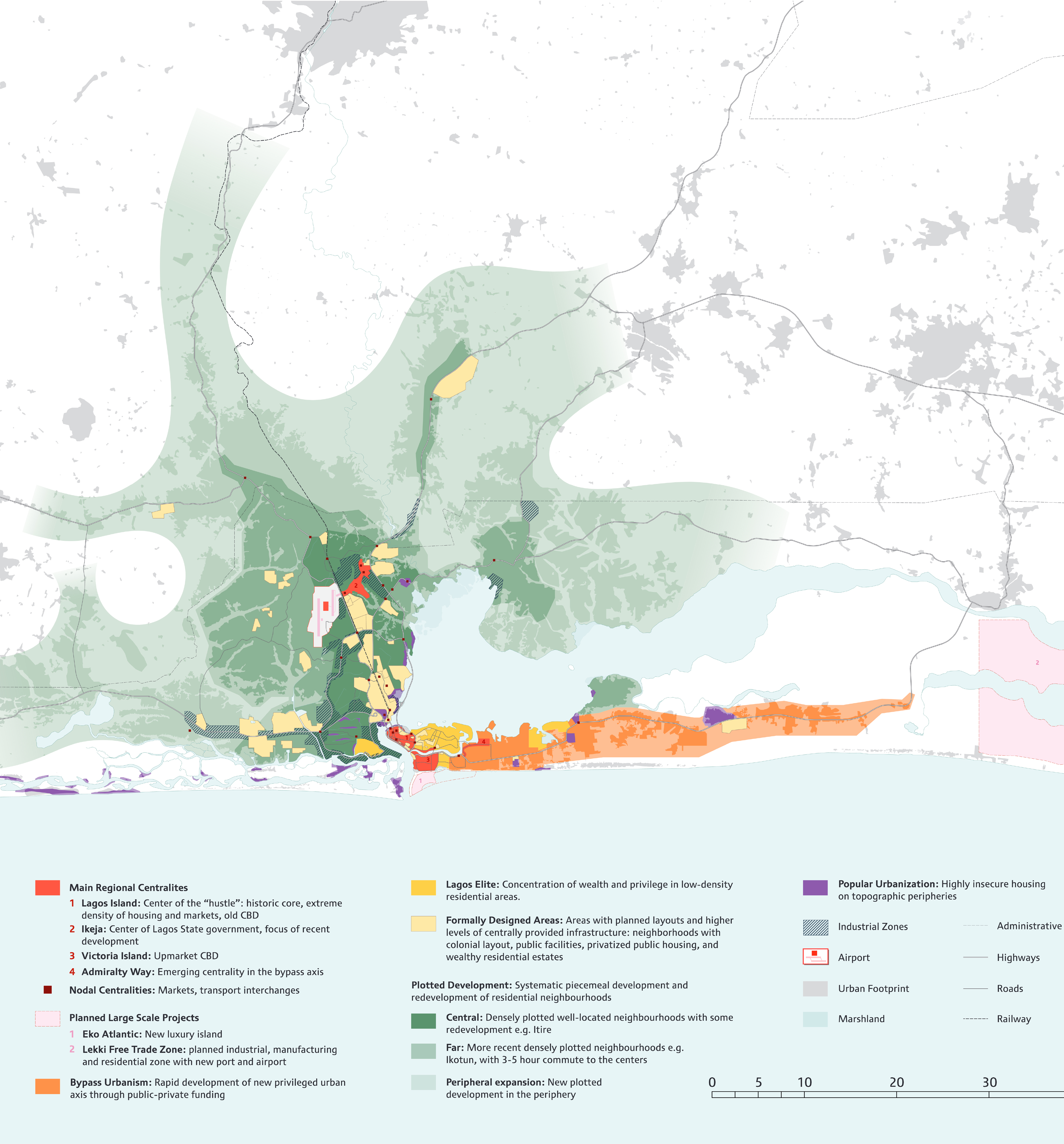
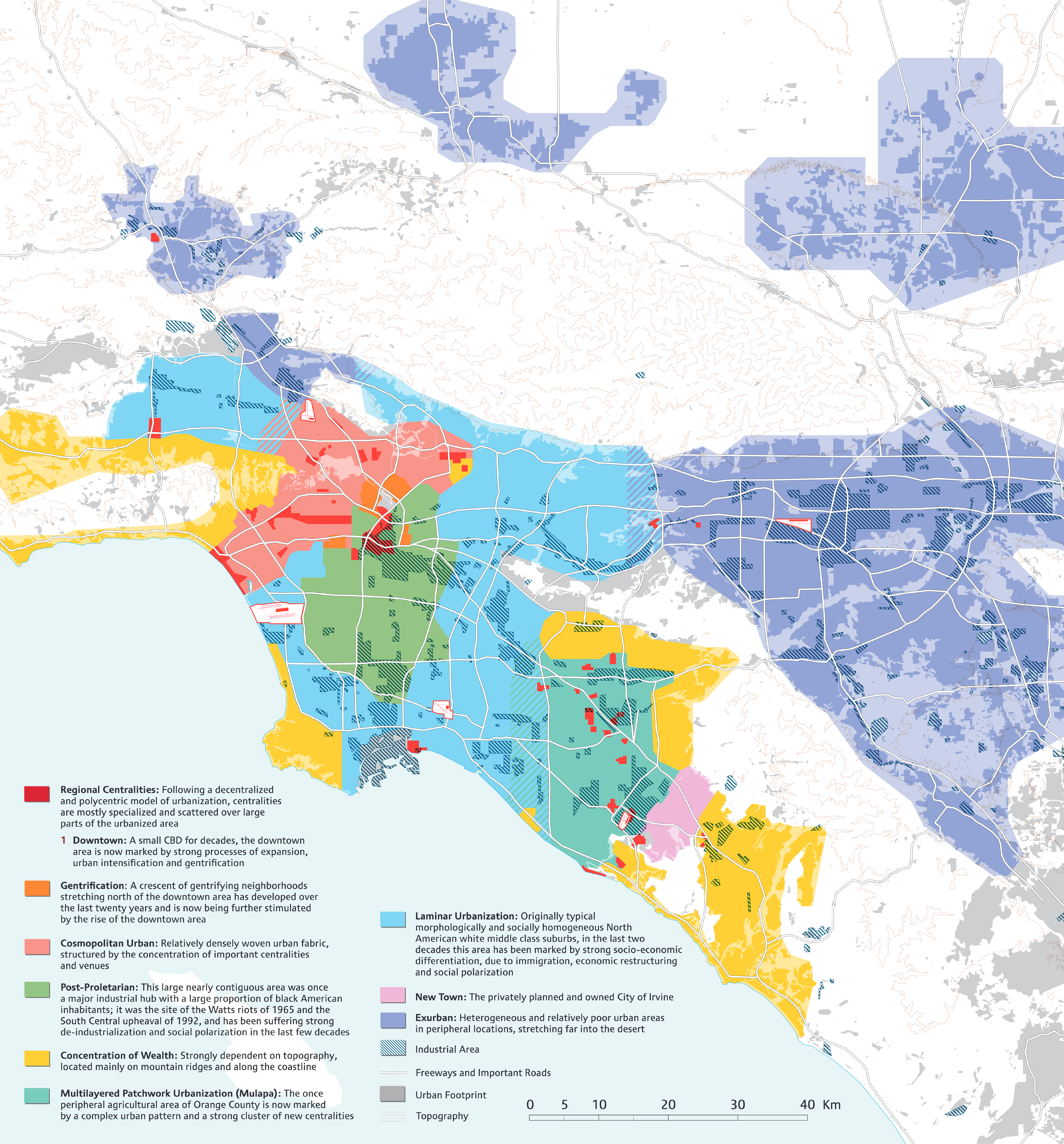
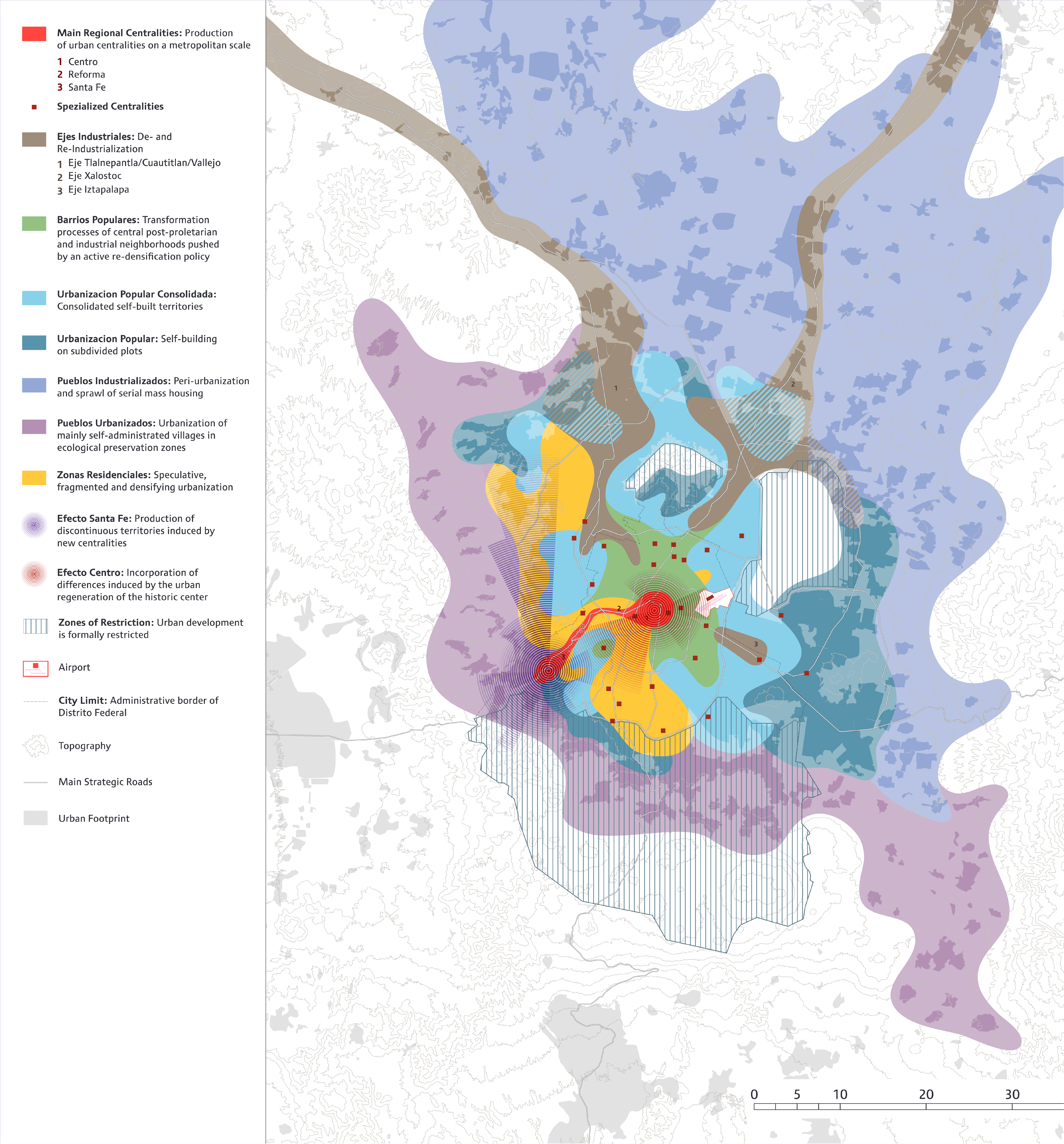
Urban configurations of Mexico City, Research and cartography by Monika Streule; Cartographic design and editing by Roger Conscience

The last two decades have seen a sharp increase in the speed, scale and scope of urbanization that has fundamentally changed the character of urban areas. Transcending physical borders, political jurisdictions and social spheres, urbanization has become a planetary phenomenon. Urban forms associated with relatively stable human settlement spaces – often represented as dots on a rural background – are superseded by increasingly heterogeneous, complex and polymorphous urban regions. This diversification of urban forms has important implications for urban planning and design. It demands a comparative and synoptic approach that can both grasp the processes of planetary urbanization and remain sensitive to the diversifying local manifestations. A new vocabulary of urbanization is required that would help us to decipher the rapidly mutating landscapes of urbanization that are today being produced across the planet.
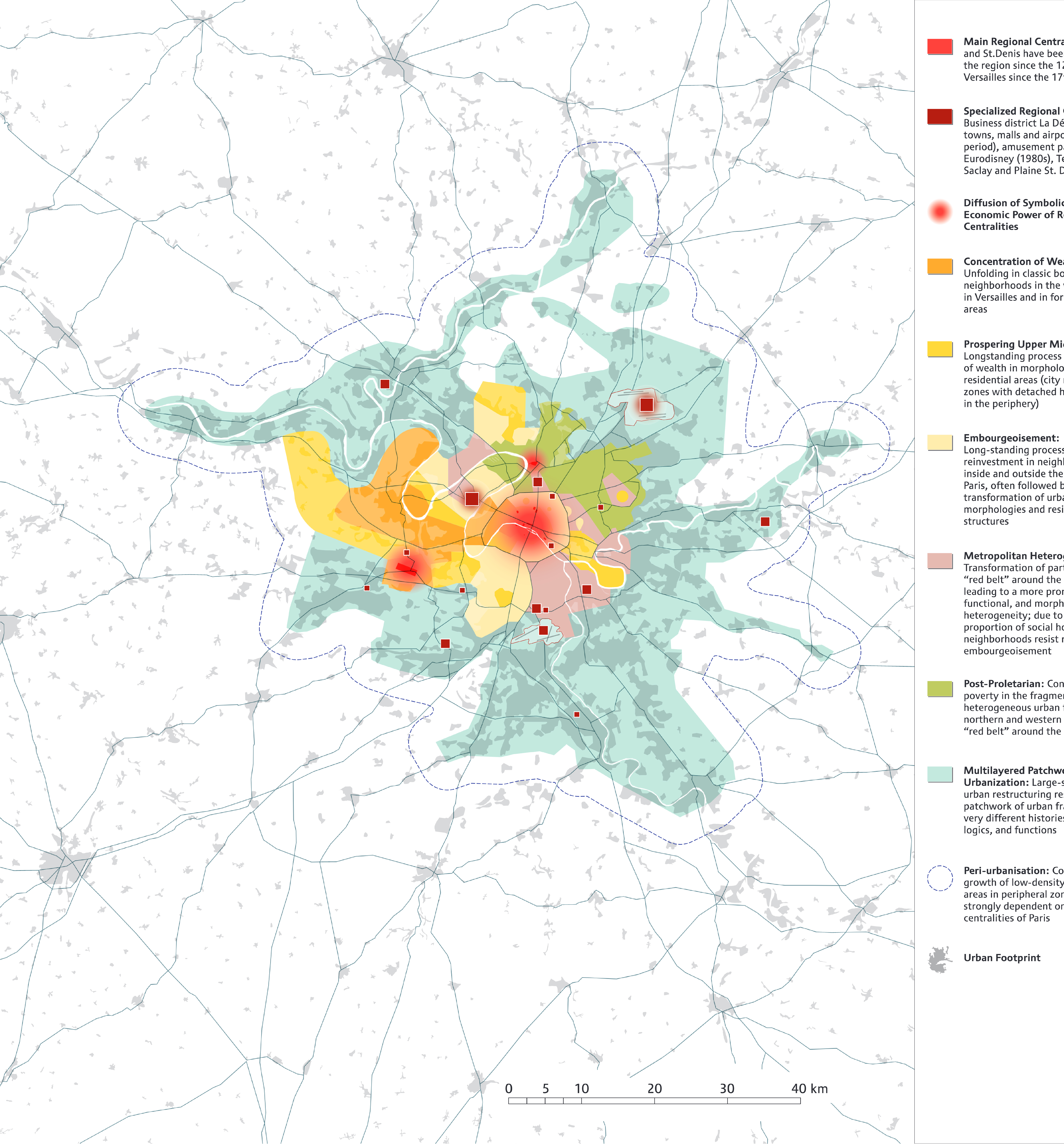
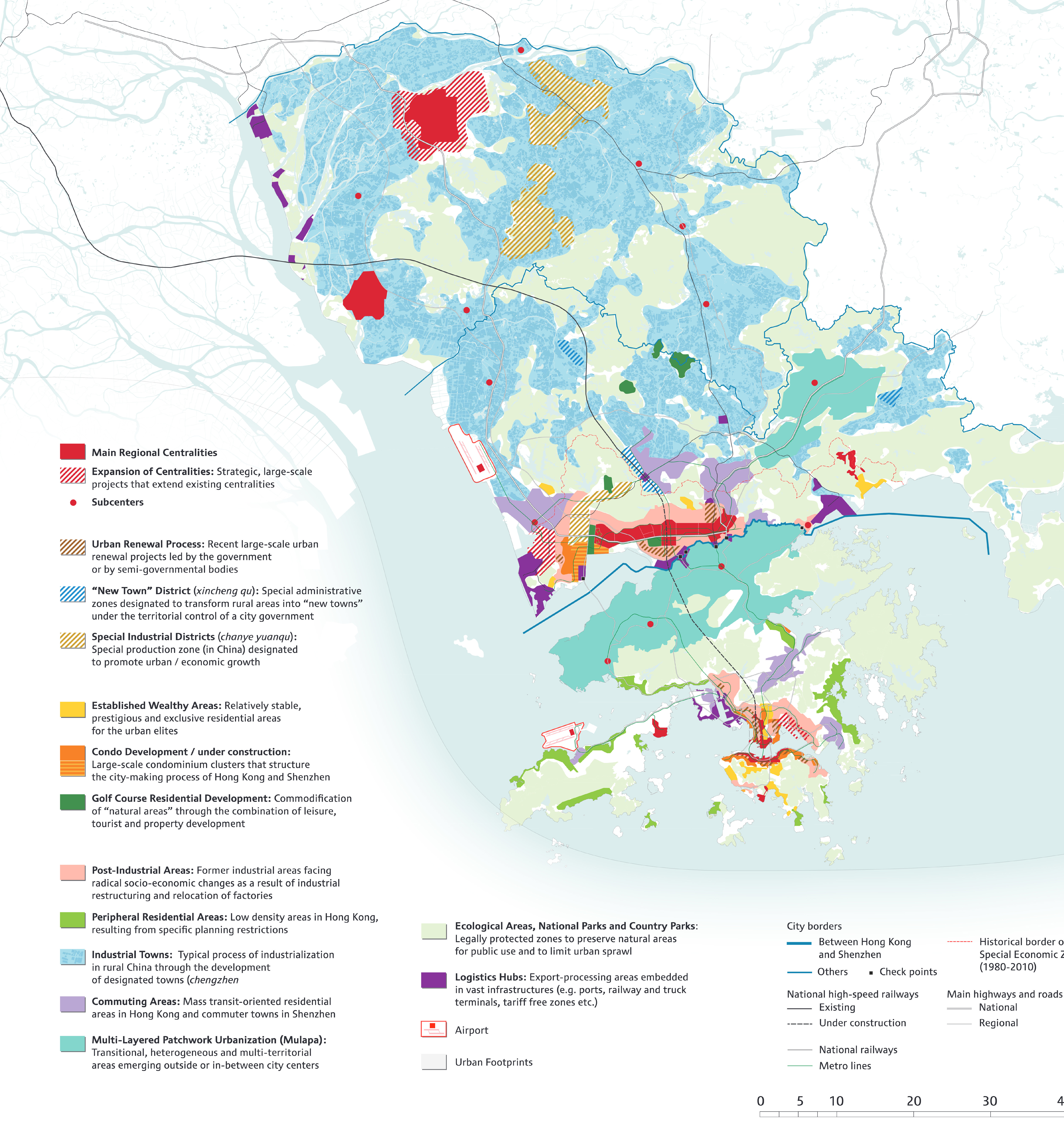
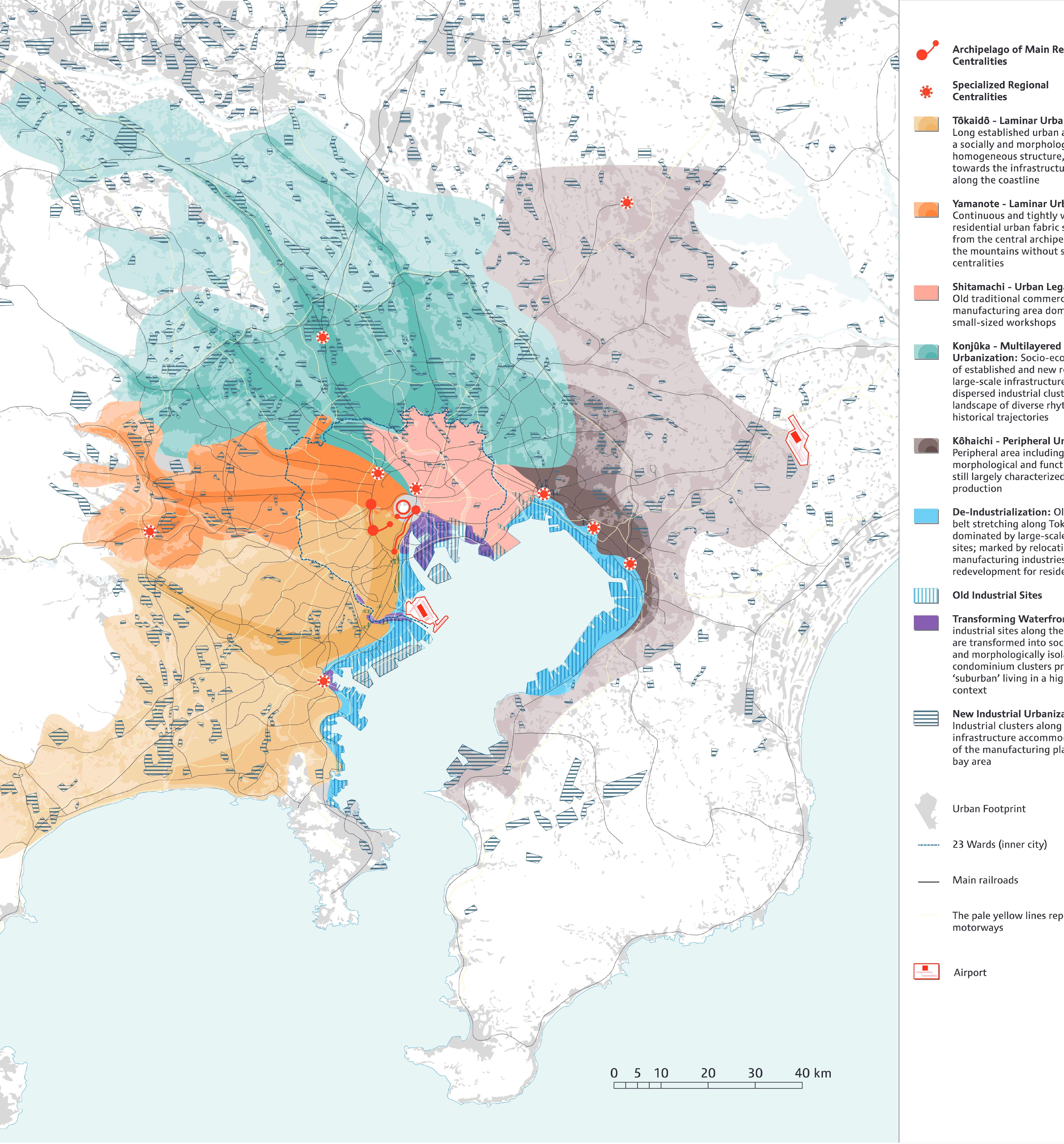
By comparing eight large metropolitan areas, this research project elaborates the processes of urbanization to explain how general tendencies are materialized in specific places. The particular processes to be compared and the categories of comparison themselves are not pre-given. We analyse the urbanization processes in the individual cities on the ground and bring them conceptually in conversation with each other.
This comparative procedure enables us to group together specific processes that have a number of common features and dynamics, and to develop a set of comparative categories of contemporary urbanization. It finally allows us to systematically analyze the diversity of responses to many of the common challenges posed by contemporary urbanization, such as urban sprawl, the commodification of urban space, socio-spatial segregation, housing for the poor, renewal of old housing stock, and the development of urban differences in terms of their effectiveness, their unintended consequences, and their ramifications for the quality of everyday urban life.

Locations Istanbul, Kolkota, Lagos, Los Angeles, Mexico City, Paris, Pearl River Delta, Tokyo
Date 2015
Team Christian Schmid, Dorothée Billard, Roger Conscience, Naomi Hanakata, Pascal Kallenberger, Ozan Karaman, Anne Kockelkorn, Philippe Rekacewicz, Lindsay Sawyer, Monika Streule, Rob Sullivan, Tammy Kit Ping Wong
Support provided by

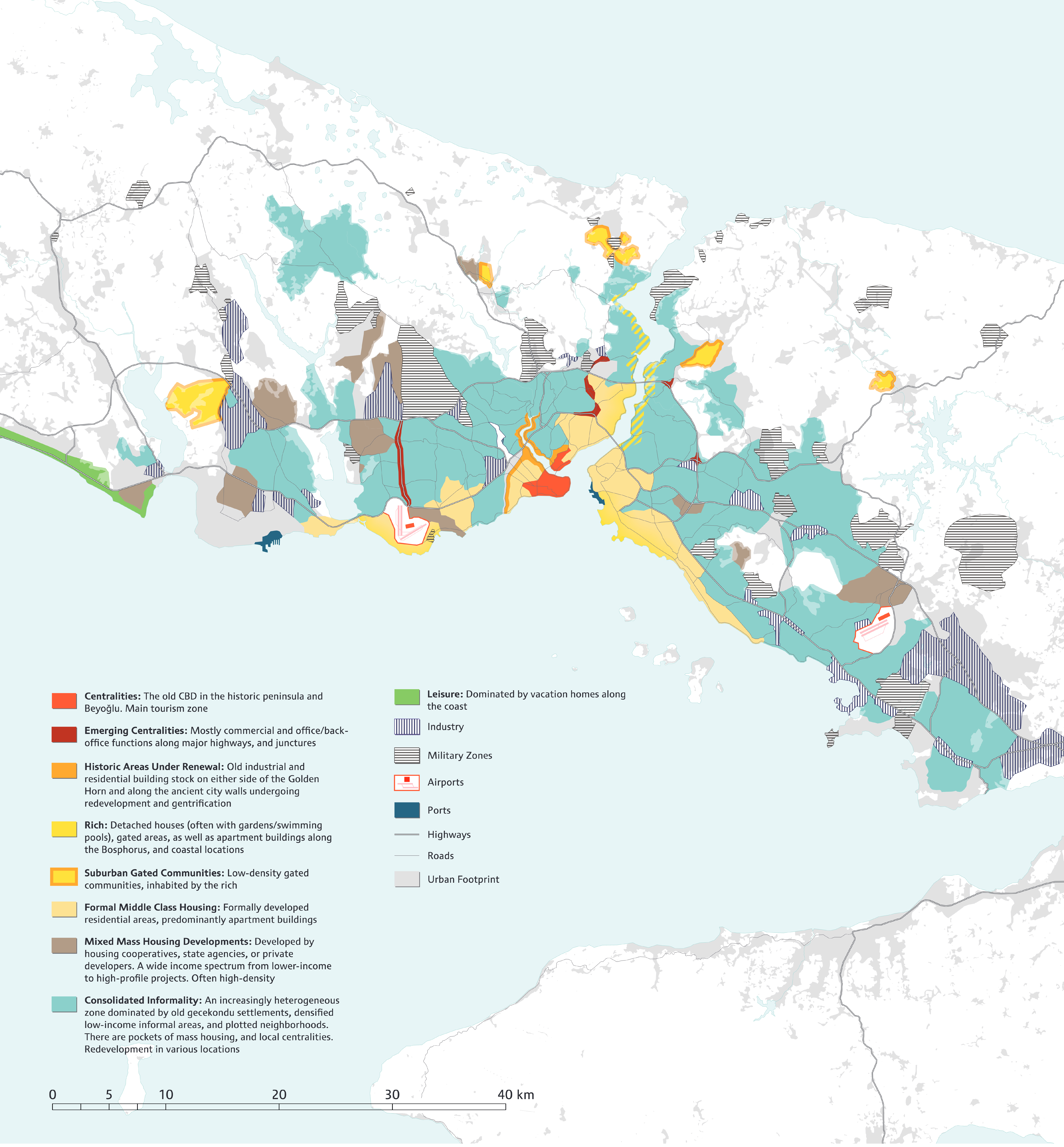
Istanbul’s urban fabric has experienced a fairly steady expansion and densification since the early 1950s. A prominent legacy of this growth has been largely informally developed territories encircling central and coastal areas. The construction of the two ring roads (the first in 1973, and the second in 1988) traversing the Bosphorus has been a major determinant in the production and transformation of urban configurations. The third ring road (under construction) is expected to encourage further growth. There is a significant push for urban renewal in large segments of the urbanized zone. Mass housing, and suburban style high-end housing have been clustering usually in peripheral areas. The urban fabric overall is increasingly heterogeneous.

Research and cartography Ozan Karaman
Cartographic design and editing Roger Conscience
Philippe Rekacewicz
Istanbul

For many decades Kolkata has been a very poor city with mostly low rise buildings and a very slow economic growth, even many years of economic stagnation, earning it the title: “city of dreadful night” by Kipling. In the last two decades the situation has changed dramatically. While the old center is experiencing an ongoing decline, the outskirts of the city have been growing at an unprecedented speed. The Eastern Metropolitan Bypass has completely reshaped the structure of the entire urban region. New condominium towers, malls, private hospitals, and entertainment parks have emerged, redirecting important parts of investments towards the new centrality, including the relocation of new local and regional governmental institutions and universities. The socially and ethnically mixed and extremely densely populated “old city” is thus bypassed by a new “modern” city emerging at the urban fringe of the metropolis.

Research and cartography Pascal Kallenberger
Cartographic design and editing Philippe Rekacewicz
Kolkota

Lagos is the city of the “hustle”: the relentless energy and creativity required just to maintain the status quo in the African continent’s largest city. It is a city of furious motion and sporadic progress where infrastructure is more often piecemeal then centralized, provided through complex strategies of self-sufficiency and networks of collaboration: a system, which applies to the richest and the poorest. Formal developments are fragmented exceptions in an urban fabric governed by the unresolved duality of customary and formal systems, and shaped by long periods of political, economic and social instability, and rapid population growth. Yet more than a decade of sustained investment in urban development and urban governance by Lagos State Government has achieved great gains and is transforming the image and future structure of Lagos. Large-scale plans are now pushing Lagos into a new phase of (unequal) urban development.

Research and cartography Lindsay Sawyer
Cartographic design and editing Philippe Rekacewicz
Lagos

Los Angeles is famous for its polycentrism as well as for its never-ending sprawl. In this map we have brought a semblance of order to a city that many have considered immanently illegible. Through months of empirical research and intensive cartographic investigations, we have parsed the region into categories, clarifying the vast and jumbled geographical sweep of Los Angeles. Thus, it becomes visible that the seemingly irregularly scattered centralities are clustered mainly in two areas, generating two very distinct core regions: a cosmopolitan zone located northwest of Downtown that includes most of the iconic places and venues of Los Angeles, and a new zone in the former southern periphery of Orange County that has become one of the paradigmatic examples of postmodern and ex-centric urban development.

Research and cartography Rob Sullivan, Christian Schmid, Ozan Karaman
Cartographic design and editing Dorothée Billard
Los Angeles

Mexico City is located in a high valley of ancient lakebeds 2300 meters above sea level at its lowest point and nearly entirely surrounded by wooded hills and volcanoes. Limited through this extreme topography, this metropolis of over 21 million inhabitants only expands towards the North and Northeast. This urban sprawl in the planes towards other regional cities is intrinsically entangled with the transformation of more central urban configurations. Beyond being reckoned as one of the biggest cities worldwide, Mexico City is thus just the core of an urbanized central territory of estimated 35 million inhabitants.

Research and cartography Monika Streule
Cartographic design and editing Roger Conscience
Mexico City

From the 17th until the mid-20th century the urban region of Paris was the center of one of the most powerful European nation states and the center of a colonial empire. The most accelerated urban growth occurred during the boom years of the post-war period, and, in parallel to the end of colonization, when the state initiated an administrative and spatial restructuring of the region through the construction of new centralities and the creation of new administrative subdivisions intended to rebalance the monocentric structure of the region. Three main processes characterize the present pattern of urbanization: first, the increasing polarization of wealth and poverty accompanied by various gentrification processes; second, the renewed effort by state administrations to strengthen the production of existing or new centralities; and third, the production of multilayered patchwork urbanization, encircling the “Capital of the 19th Century“ at an approximate distance of 15 kilometers.

Research and cartography Anne Kockelkorn, Christian Schmid
Cartographic design and editing Dorothée Billard
Paris

The Eastern side of the Pearl River Delta can be characterized as a multi-scalar, polycentric and cross-border metropolitan area. This territory has emerged from the dialectics of fixity and motion that has triggered the leapfrogging urbanization of South China. It consists of different political administrative systems and uneven power relations in Hong Kong, Shenzhen and Dongguan, and has developed from the collision of the two radically different regimes of socialism and capitalism. The territorial logics of power through the use of border demarcations, zoning and administrative restructuring have produced particular urban configurations at different geographical scales.
Such differentiated and hierarchical territorial structures are anchored by heavy infrastructures for the circulation of people, capital and commodities. 30 million people and important transnational and domestic capitals are concentrated here and move rapidly through it thus defining a very complex and dynamic regional economic entity.

Research and cartography Tammy Kit Ping Wong
Cartographic design and editing Philippe Rekacewicz
Pearl River Delta

Tokyo has been an important centrality within Japan since 1600, and it has developed a finely differentiated pattern of urbanization with a strong structural resilience on the one hand and a dynamic that is creating an ever-changing appearance of the city on the other. The urban development of Tokyo since the mid-19th century was closely linked to the development of a railway system, which pushed the fringe of the city further and further outwards.
Most recently, urbanization processes are concentrating again on the urban core, producing a densification in the heart of Tokyo while the peripheral areas are confronted with the downside of restructuring processes and the consequences of an aging society. On the regional scale, Tokyo with its 43 million inhabitants is today highly monocentric as global networks, people, goods, information and power are converging in the heart of the city. At the scale of the city core, this center is highly fragmented and differentiated into specialized areas.

Research and cartography Naomi Hanakata
Cartographic design and editing Dorothée Billard, Philippe Rekacewicz
Tokyo