Projects & Research

Agroecological Design for the Zürich Region

Agroecological Region Zürich: A synthesis of seven Agriterritories of Potential for Agroecological Change. Research and Cartography: Karoline Kostka, 2023.

The study proposes a new territorial thesis for Zürich as an “Agroecological Region,” encompassing various population densities, infrastructures, production surfaces, natural resources, and ecological features, striving to balance urbanisation with agriculture and natural environments, promoting sustainable and ecologically production and lifestyles. Employing this new concept, the development of regional research approaches and hybrid design agendas within identified “Agriterritories of Potentials” by highlighting existing opportunities. The project aims to emphasise nature-based design solutions that counter the prevailing reliance on technological fixes and challenge the attempts of agroecological priorities in spatial planning and equitable governance across the functional and ecological metropolis.
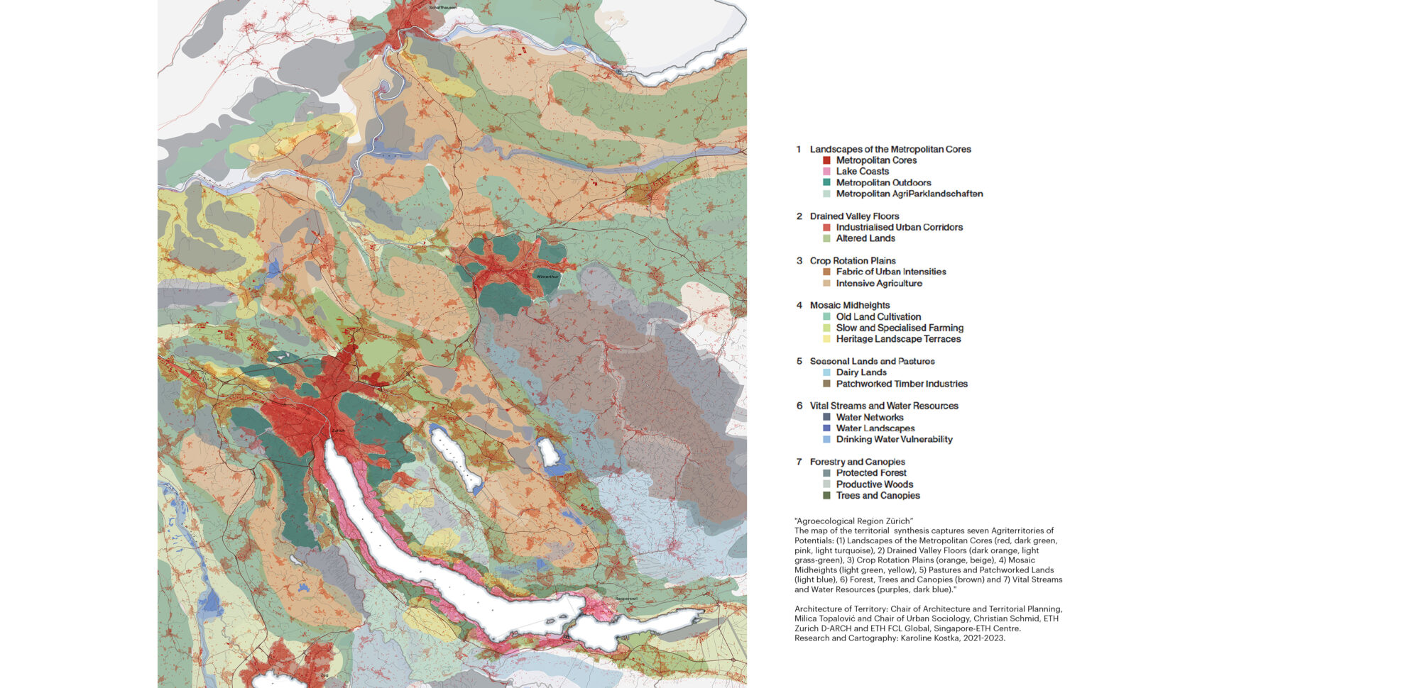
Addressing the complex interactions between urbanisation, agriculture, and ecological sustainability in the planning and land governance of Metropolitan Regions has become increasingly crucial in the face of agroecological priorities and transition. With this, nature-based design solutions counter the prevailing reliance on technological fixes and challenge attempts of spatial planning and equitable governance across the functional and ecological metropolis.

By proposing the concept of an "Agroecological Region" and identifying "Agriterritories of Potentials for Agroecological Change", the research seeks to establish a framework that integrates various elements—population densities, infrastructure, natural resources, and ecological features— to support sustainable and ecologically conscious production and living.

The study conceptualises seven composite urbanisation typologies in agricultural land. These novel hybrid land categories have emerged as a result of comprehensive regional fieldwork and were developed incrementally through cartography, utilising a non-automated quantitative and qualitative multi-criteria analysis alongside scholarly, empirical, and ethnographic investigations. The approach aligns over two hundred indicators, including relational, physical, geomorphological, ecological, social, political, and cultural factors. It links them to changes in land use patterns, soil functionality, and ecosystem services, covering high and low-density areas. The devised Agriterritories consolidate specific agroecological potentials, address challenges, and outline actionable areas within each composite category.

The framework further offers large-scale urban-territorial design agendas in each emerging land typology, foregrounding strategies based on the principles of agroecology and sustainable urban development. Operating integratively across multiple scales, they emphasise critical territorial transformation and design objectives stemming from their identified inherent potential for an Agroecological Region Zürich.

Research and cartography Karoline Kostka
Date 2020-2023

Apart from supplying food, agricultural areas provide various other services such as habitat for species, aesthetic values, recreational opportunities, and so-called nature’s contributions to people (NCPs). Knowledge of spatiotemporal fluctuations in the supply of and demand for NCPs is essential to manage these landscapes for multifunctionality. The goal of this research is to analyse these trends. The NCP “pollination” is discussed here, but similar analyses are planned for the following NCPs: habitat quality, recreation, food and feed, climate, and freshwater. For pollination, the supply is computed with the InVEST Crop pollination model, while the demand is calculated as crop pollination dependence. The pollination supply and demand distribution shows clear, contrasting spatial patterns (see map). Over time, agricultural land has steadily decreased while the amount of grown pollination-dependent crops has increased. Pollinator abundance values have shown a steady decline in the past, with a slight increase in the last decade (see graph). Landscape changes explain the shift in pollinator abundance, while societal demand, like new lifestyles and consumption habits, drives the change in crop types. This changes trade-off dynamics over time, with associated claims and differences that give ground to novel management opportunities.

Research Matteo Riva
Dates 2020-2023

Agroecological systems are built upon their soils. Yet, soil quality is often ignored outside of agricultural production. Even there, soils are unsustainably degraded by intensive agriculture while inputs temporarily mitigate their shortcomings. Soils are multifunctional systems determined by their physicochemical properties, histories, and management. We expanded upon existing rural soil functional assessments to determine how urbanisation has affected soil function. Six soil functions were estimated from soil properties (Water Regulation, Carbon Sequestration, Pollution Regulation, Nutrient Retention, Agricultural Potential, and Biodiversity Support). While no soil can be best at providing every function, degraded, stony, and compacted soils are limited in which functions they can supply. Below is a comparison of extremes. Soil A is a high-quality agricultural soil from the Limmattal that is threatened by urban expansion. Its balanced texture, low compaction, and stone content allow for both nutrient and water regulation while still being excellent agricultural soils. Soil B is from the rugged Toggenberg hills. Due to persistent erosion, these soils provide limited functions due to their high stone content and slope with minimal topsoil.

Research Kevin Vega
Dates 2020-2023
IMG20230320172740 1
IMG20230322141956 1
IMG20230322145235 1
IMG20230320133518
IMG20230526101232
DSC 0494